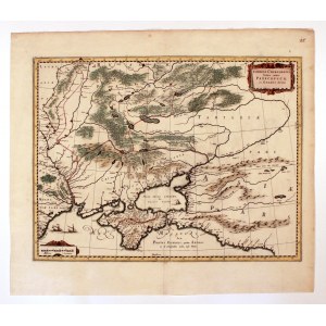
UKRAINE, KRYM. Map of Ukraine with Crimea; compiled by. Willem Janszoon Blaeu, Amsterdam, ca. 1640; verso clean; copper color, st. bdb., small tear at bottom of atlas fold; plate dimensions: 502x382 mm; title in upper right corner, in scroll cartouche: TAVRICA CHERSONESVS, Nostra aetate PRZECOPSCA, et GAZARA dicitur.
For European artists of the modern era, which included W. Bleau, the ancient world has not passed away at all. The map shows the ancient name of Crimea - Tavrica Chersonesvs, in Polish " Chersonese Taurida". This name distinguished it from the other Chersonese, called Thracian, today the Gallipoli peninsula in the European part of Turkey. Bleau would not have been himself if he had not included precisely the ancient variant of the peninsula's name in his work. In doing so, the map explains what happened to the Tauride Chersonese until the author's contemporaries. He divided it by the border visible on the map into Przecopsca and Gazara. The latter is also known as Gazaria, a union of Italian Genoa colonies located on the northern coast of the Black Sea and present-day Romania. They existed for more than 200 years: from 1261 to 1475, when Gazaria's capital, Kaffa (called Theodosia in ancient times) was captured by the Ottoman Turks. At the end of its existence, Kaffa enjoyed the protectorate of Casimir the Jagiellonian.
The northern part of Crimea and the territory to the north Bleau called Krimea seu Tartaria Przekopensis. This is nothing but the state of the Crimean Tatars. He drew its boundaries: the lower course of the Dniester, to the mouth of the Vorskla River and then with the course of the Don to Azov. In turn, Przecopsc is a narrow isthmus from Crimea to the north, on which the Tatars built a fortress - today Perekop. The Lower Dniester was the border between Bessarabia and Podolia.


![Dahlberg Erik Jonsson [Puffendorf] - Signing of the peace treaty between the kingdoms of Sweden and Denmark on May 27, 1660.](https://img1.one.bid/img/5856/1830504_1x.webp?1712095200)