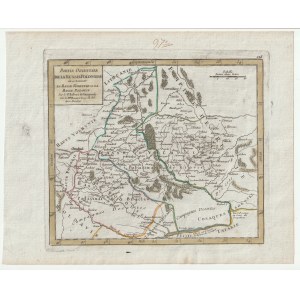
UKRAINE - Kiev and Braclaw provinces. Issued by D. Robert de Vaugondy, Paris, ca. 1740; copper color, st. bdb; plate dimensions: 202x180 mm; PARTIE ORIENTALE DE LA RUSSIE POLONOISE òu se trouvent LA BASSE VOLHYNIE ET LA BASSE PODOLIE.
The map shows the division of the Kiev province between the First Republic and Russia. It was a consequence of the so-called Androsh truce of 1667, according to which Moscow was to enter Kiev for only two years. Nothing of the sort happened, because in the so-called Peace of Grzymułtow of 1686 the First Republic recognized Moscow's rights to Kiev. The consequences of the division of the then Kiev province reach the present day. Geopolitically, this was the greatest tragedy for all the nations that made up the First Republic and the pragenesis of today's war in Ukraine. The map shows the territory of the Zaporozhian Cossacks and Petit Tatarie ("Little Tartary," or Crimean Khanate) and the Khanate of the Oczak Tatars, or Yedisan.