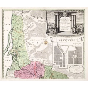
Klaipeda, GUBIN (now Gusev, Russian: Гусев). Map of the districts of Klaipeda, Tilsit, Ragneta (now Nieman, Russian: Неман) and Instenburg (now Chernyakhovsk, Russian: Черняховск) on two separate sheets; publ. Heirs of Homann, Nuremberg 1735; decorative cartouche in upper right corner, below a schematic plan of Gabin - PLAN von der in Lithauen neu angelegten Stadt GUMBINNEN, and a small scale cartouche; copper color, st. bdb., slight tear at bottom of one of the sheets; plate dimensions approx. 596x500 mm, dimensions of map when folded 580x980 mm; Potentissimo BORUSSORUM REGI FRIDERICO WILHELMO Majesate Fortitudine Clementia Augustissimo Hancce LITHUANIAM BORUSSICAM in qva loca colonijs Salisburg. ad incolendum Regio nutu concessa chorographice exhibentur DDD REGIAE SUAE MAIESTATIS [...]; [Prussia-Karten 304].
![[MAP]. MAP OF POLAND 1 : 500 000. OLSZTYN. [Sheet ] 3. w-wa 1947....](https://img1.one.bid/img/6363/1859794_1x.webp?1713045600)