


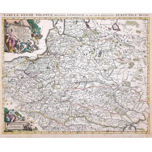
Mapa ziem Rzeczpospolitej, stan szósty, wyd. Jan Barend Elwe, Amsterdam, 1792
miedzioryt kolorowany w epoce, 49,5 x 60,7 cm (odcisk płyty)
stan zachowania bardzo dobry
Imago Poloniae, K19/6


![Poland car map. Cracow [1945].](https://img1.one.bid/img/6508/1873705_1x.webp?1713823200)
![Poland car map. Cracow [1945].](https://img1.one.bid/img/6508/1873705_2x.webp?1713823200)
![[MAP]. MAP OF POLAND 1 : 500 000. OLSZTYN. [Sheet ] 3. w-wa 1947....](https://img1.one.bid/img/6363/1859794_1x.webp?1713045600)
![[DE FER Nicholas] STETIN ville Forte d'Allemagne [SZCZECIN - Fortified City of Germany, Capital of Royal Pomerania] Paris. 1691.](https://img1.one.bid/img/6508/1873735_1x.webp?1713823200)
![[DE FER Nicholas] STETIN ville Forte d'Allemagne [SZCZECIN - Fortified City of Germany, Capital of Royal Pomerania] Paris. 1691.](https://img1.one.bid/img/6508/1873735_2x.webp?1713823200)


Laatst bekeken
Log in om de kavellijst in te zien
Favorieten
Log in om de kavellijst in te zien