


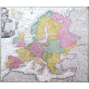
Mapa Europy pochodząca z „Atlas Novus sive Tabulae Geographicae Totius Orbis Faciem”, ok. 1740
miedzioryt kolorowany, 49 x 57,5 cm w świetle oprawy


![Dahlberg Erik Jonsson [Puffendorf] - Dyneburg.](https://img1.one.bid/img/5856/1830362_1x.webp?1712095200)


![Dahlberg Erik Jonsson [Puffendorf] - Urbis et Arx Mitovia. .. Dobbleena Arx Cellciss. Curlandiae](https://img1.one.bid/img/5856/1830363_1x.webp?1712095200)


Laatst bekeken
Log in om de kavellijst in te zien
Favorieten
Log in om de kavellijst in te zien