


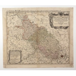
SLĄSK. General map of Silesia, compiled by. Tobias Mayer, 1749, taken from: Atlas Silesiae [...], published by Oficyna Spadkobierców Homanna, Nuremberg 1750; copper color, st. db, after conservation, soiling and yellowing, traces of moisture, minimal tears; plate dimensions 570x485 mm; DVCATVS SILESIAE Tabula geographica generalis [...]; above upper frame, second title: LE DVCHE DE SILESIE, suivant l'état présent. dressé par TOBIE MAIER [...].


![[MAP]. MAP OF POLAND 1 : 500 000. OLSZTYN. [Sheet ] 3. w-wa 1947....](https://img1.one.bid/img/6363/1859794_1x.webp?1713045600)
![Poland car map. Cracow [1945].](https://img1.one.bid/img/6508/1873705_1x.webp?1713823200)
![Poland car map. Cracow [1945].](https://img1.one.bid/img/6508/1873705_2x.webp?1713823200)
![Map of Bydgoszcz area [ca] 61x45, [post 1922].](https://img1.one.bid/img/6474/1885259_1x.webp?1714687200)
![Map of Bydgoszcz area [ca] 61x45, [post 1922].](https://img1.one.bid/img/6474/1885259_2x.webp?1714687200)
![Dalhberg Erik Jonsson [Puffendorf] - Map of the Kingdom of Denmark and Pomerania (Szczecin)](https://img1.one.bid/img/5856/1829209_1x.webp?1712008800)


Recently viewed
Please log in to see lots list
Favourites
Please log in to see lots list