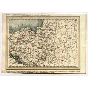
WIELKIE KSIĘSTWO POZNAŃSKIE, KRÓLESTWO POLSKIE. Mapa Królestwa Polskiego, Wielkiego Księstwa Poznańskiego, Śląska i Prus; anonim
addYour notecreate
Lot description
WIELKIE KSIĘSTWO POZNAŃSKIE, KRÓLESTWO POLSKIE. Mapa Królestwa Polskiego, Wielkiego Księstwa Poznańskiego, Śląska i Prus; anonim, 1844; lit. cz.-b. z kolorem liniowym, st. bdb.; wym.: 190x138 mm; tyt. nad górną ramką: KARTE vom KÖNIGREICH POLEN und den preus. Prov. Schlesien Ost u. Westpreussen u. Posen;
LabelsBETA
Labels are assigned by artificial intelligence based on the recognized context of the image. The algorithm is constantly learning and we make every effort to make the results more accurate over time.
![[MAP]. MAP OF POLAND 1 : 500 000. OLSZTYN. [Sheet ] 3. w-wa 1947....](https://img1.one.bid/img/6363/1859794_1x.webp?1713045600)