


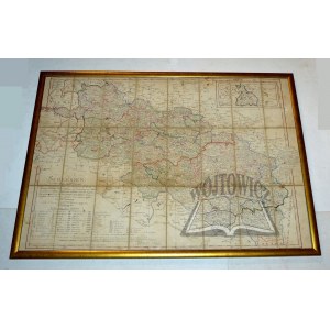
( SILESIA). "Schlesien nach dem Tilsiter Frieden und nach dem Wielandschen Atlas,
den Beyträgen des Herrn Kammercalculators Zimmermann zur Beschreibung von Schlesien und andern vorzüglichen Hülfsmitteln bearbeitet, nach den beyden Kammerdepartements und den dazu gehörigen landrätlichen Kreisen abgetheilt und mit den neu angelegten Post-Coursen versehen von D.F. Sotzmann." Copperplate on canvas, colored linearly. Nürnberg 1810. dimensions: 56 x 80 cm.
Title with publisher's note in lower left corner, below is an explanation of the numbering used for the administrative divisions delineated on the map. At the bottom a linear scale in miles. In the upper right corner a carton with the Świebodzin district, next to it a legend. The map was based on maps from Atlas Silesiae by J.W. Wieland and M. Schubarth from 1752. First published in 1800, later reissued several times. The 1810 edition was compiled after the peace of Tilsit (1807). Traces of dampstain and soiling, pencil notations, visible folding marks of the fence. Map in frame behind glassine.


Recently viewed
Please log in to see lots list
Favourites
Please log in to see lots list