


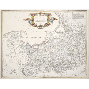
KINGDOM AND PRUSSIA PRUSSIA. Map of Prussia; compiled by. G. de Vaugondy, ryt. G. Delahaye, taken from: Atlas Universel, map compiled. 1751, published Paris 1757; filigrees; copper colored, condition bdb., paper yellowed, small tear at bottom, several small dark spots; plate dimensions 630x500 mm; title in decorative cartouche: LA PRUSSE divisée en PRUSSE ROYALE, et PRUSSE DUCALE [...]; [Prussia-Karten... 130].


![[MAP]. MAP OF POLAND 1 : 500 000. OLSZTYN. [Sheet ] 3. w-wa 1947....](https://img1.one.bid/img/6363/1859794_1x.webp?1713045600)
![Poland car map. Cracow [1945].](https://img1.one.bid/img/6508/1873705_1x.webp?1713823200)
![Poland car map. Cracow [1945].](https://img1.one.bid/img/6508/1873705_2x.webp?1713823200)


![Dalhberg Erik Jonsson [Puffendorf] - Map of the Kingdom of Denmark and Pomerania (Szczecin)](https://img1.one.bid/img/5856/1829209_1x.webp?1712008800)


Recently viewed
Please log in to see lots list
Favourites
Please log in to see lots list