


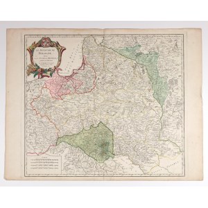
POLAND (called KORONA in the First Republic), GREAT PRINCE OF LITHUANIA. Map of the lands of the Commonwealth; published by Gilles and Didier Robert de Vaugondy, Paris after 1772; title cartouche in upper left hand corner, scalloped frame in lower left hand corner; copper partly colored, st. db, from verso map fold glued with paper, minor corner folds, mild soiling; plate dimensions 560x500 mm; LE ROYAUME DE POLOGNE, divisé en ses DUCHES et PROVINCES, et subdivisé en Palatinats. Par le Sr. ROBERT DE VAUGONDY Géographe ordinaire du Roi. Avec Privilége 1752.


![[MAP]. MAP OF POLAND 1 : 500 000. OLSZTYN. [Sheet ] 3. w-wa 1947....](https://img1.one.bid/img/6363/1859794_1x.webp?1713045600)
![Poland car map. Cracow [1945].](https://img1.one.bid/img/6508/1873705_1x.webp?1713823200)
![Poland car map. Cracow [1945].](https://img1.one.bid/img/6508/1873705_2x.webp?1713823200)


![Dalhberg Erik Jonsson [Puffendorf] - Map of the Kingdom of Denmark and Pomerania (Szczecin)](https://img1.one.bid/img/5856/1829209_1x.webp?1712008800)


Recently viewed
Please log in to see lots list
Favourites
Please log in to see lots list