


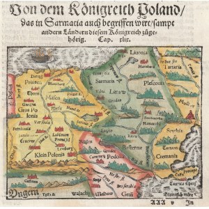
POLAND (called CORONA in the First Republic). One of the first maps of Poland; taken from: Münster, Sebastian, Cosmographia, published by Henric Petri, Basel, after 1552 (the year of the first French edition), German edition 1567; above the upper frame text: Von dem Vngerland; a complete page from the book; wood. col., st. bdb., light soiling, minimal edge tears; map dimensions 153x120 mm, card dimensions 205x320 mm; Von dem Koenigreich Poland das in Sarmatia auch begriffen wirt [...]. [cf. Imago Poloniae... K6/2].


![[MAP]. MAP OF POLAND 1 : 500 000. OLSZTYN. [Sheet ] 3. w-wa 1947....](https://img1.one.bid/img/6363/1859794_1x.webp?1713045600)


Recently viewed
Please log in to see lots list
Favourites
Please log in to see lots list