


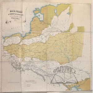
(POLAND). Map of Poland within its former boundaries published for use by schools in Cracow 1871.
Litografdia Czasu, M. Salba in Krakow Nakł. Dr. Adrian Baraniecki. Color lithograph, 1871. map on canvas, Dimensions: 118 x 118 cm.
In the upper corner information about the map, in the lower corner explanation of the signs. Large size map, folded on linen, with traces of unsoiling and tears at edges.


![[MAP]. MAP OF POLAND 1 : 500 000. OLSZTYN. [Sheet ] 3. w-wa 1947....](https://img1.one.bid/img/6363/1859794_1x.webp?1713045600)


![Königl. Freistadt Oedenburg [Sopron szabad királyi város térképe, 1871.] Lithographiert von F. Szita. W[iene]r...](https://img1.one.bid/img/6570/1844246_1x.webp?1712700000)
![Königl. Freistadt Oedenburg [Sopron szabad királyi város térképe, 1871.] Lithographiert von F. Szita. W[iene]r...](https://img1.one.bid/img/6570/1844246_2x.webp?1712700000)


Recently viewed
Please log in to see lots list
Favourites
Please log in to see lots list