


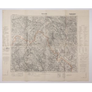
OSTRÓDA. Topographical map of the Ostroda area, Susz to the north, Brodnica to the south, scale 1 : 100,000, issued 1936, legend, p.b.; st. bdb., folded, handwritten annotation in pen on verso; dimensions ca. 880x725 mm; Großblatt Nr. 43 Osterode.


![[MAP]. MAP OF POLAND 1 : 500 000. OLSZTYN. [Sheet ] 3. w-wa 1947....](https://img1.one.bid/img/6363/1859794_1x.webp?1713045600)


![Dalhberg Erik Jonsson [Puffendorf] - Map of the Kingdom of Denmark and Pomerania (Szczecin)](https://img1.one.bid/img/5856/1829209_1x.webp?1712008800)


Recently viewed
Please log in to see lots list
Favourites
Please log in to see lots list