


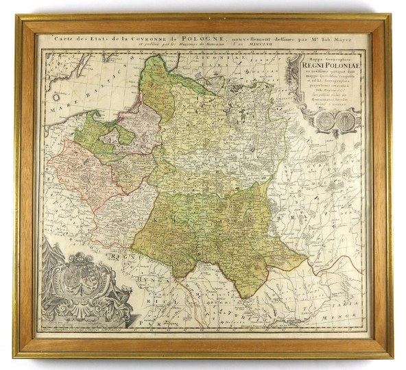
[POLAND]. Mappa Geographica Regni Poloniae ex novissimis quotquot sunt mappis specialibus composita et ad LL. stereographica projectionis revocata [...]. Colorized copperplate form. 44.9x51.7 cm.
Imago Pol. K44/4; Krassowski 34. Map of Poland by Tobias Mayer, published in Nuremberg by the outhouse of Homann's Heirs in 1757 (this is the date in the title). Title in upper right corner, in cartouche with obverse and reverse of coin (no color). Above the upper frame a second title: "Carte des Etats de la Couronne de Pologne [...]". In the lower left corner two shields of arms (of Poland and Lithuania and the Wettins) surrounded by trees, wild animals, weapons (no color). Line and surface color. Folds in the middle part of the sheet, small trace of dampness in the upper left corner.


![[MAP]. MAP OF POLAND 1 : 500 000. OLSZTYN. [Sheet ] 3. w-wa 1947....](https://img1.one.bid/img/6363/1859794_1x.webp?1713045600)
![Automobile MAP of Poland 1 : 2,000,000 with list of gas stations by 'Karpaty' Nakł. Karpaty Sp. z o.o., Lviv [1933].](https://img1.one.bid/img/6145/1794990_1x.webp?1709593200)
![Automobile MAP of Poland 1 : 2,000,000 with list of gas stations by 'Karpaty' Nakł. Karpaty Sp. z o.o., Lviv [1933].](https://img1.one.bid/img/6145/1794990_2x.webp?1709593200)


Recently viewed
Please log in to see lots list
Favourites
Please log in to see lots list