


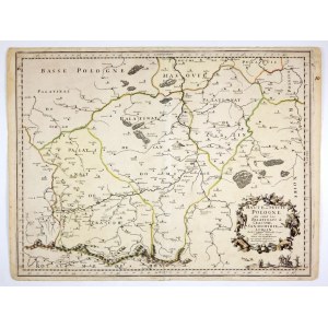
[SouthernPoland ]. Haute, ou Petite Pologne ou sont les Palatinats de Cracow, Sandomirie, et Lublin. Copperplate colored engraving form. 42.5x55.6 cm.
Imago Pol. K85/1. Map of southern Poland by Nicolas Sanson, first state of plate, published in Paris by Pierre Mariette in 1666 (this is the date in the cartouche). It was published as one of a series of 15 maps of Polish lands prepared by Sanson. The title cartouche in the lower right corner, with two horsemen and a group of footmen below it. The map covers the area south of Warsaw. Line color. Verso clean, with handwritten number 10. Visible center fold, repaired bottom edge tear, margin stains.


Recently viewed
Please log in to see lots list
Favourites
Please log in to see lots list