


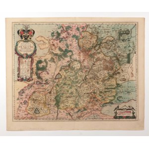
GŁOGÓW. map of the Duchy of Głogów; first state, compiled by. Jonas Scultetus, published by Johannes Janssonius, Amsterdam 1647; eastern orientation, text in Latin on verso: GLOGAW DUCATUS; copper. color, f.d., minimal edge tears; plate dimensions 530x417 mm; DVCATVS SILESIAE GLOGANI Vera Delineatio [...]; [cf. Silesia in old... 55, Imago Silesiae... 46].


Recently viewed
Please log in to see lots list
Favourites
Please log in to see lots list