


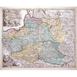
Map of the lands of the Rzeczpospolita, second state, published by Pieter Mortier, Amsterdam, 1696
copperplate engraving colored in epoch, map size 48.5 x 61 cm
good condition +
rarity
Imago Poloniae, K19/2


![[DE FER Nicholas] STETIN ville Forte d'Allemagne [SZCZECIN - Fortified City of Germany, Capital of Royal Pomerania] Paris. 1691.](https://img1.one.bid/img/6508/1873735_1x.webp?1713823200)
![[DE FER Nicholas] STETIN ville Forte d'Allemagne [SZCZECIN - Fortified City of Germany, Capital of Royal Pomerania] Paris. 1691.](https://img1.one.bid/img/6508/1873735_2x.webp?1713823200)


Recently viewed
Please log in to see lots list
Favourites
Please log in to see lots list