


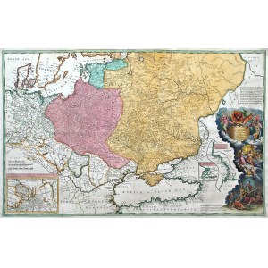
Map of Russia, Poland, the Crimean Khanate and the Black Sea, ed. by H. Moll, D. Midwinter, P. Overton, T. Bowles, second state, ca. 1722
colored copperplate, 62.7 x 99.5 cm (plate imprint); framed
very good condition
Imago Poloniae, K40/2


Recently viewed
Please log in to see lots list
Favourites
Please log in to see lots list