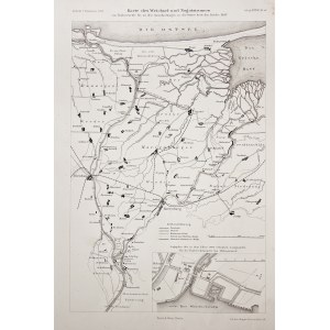
VISTULA AND MALBORK ZULAWY. Map of the course of the Vistula River and the Nogat River (and other watercourses) in the section from the village of Rudniki to the mouth of the Baltic Sea and the Vistula Lagoon; at the bottom, a frame with a plan of the port for Vistula icebreakers in Płoni Wielka (today a settlement of Gdańsk); lith. in B. Gisevius, 1888; litho p.b., st. bdb., very minor rust spots; sheet dimensions 285x446 mm; Karte des Weichsel- und Nogatstromes von Rudnerweide bis zu den Ausmündungen in die Ostsee bezw. das frische Haff.
![Dalhberg Erik Jonsson [Puffendorf] - Map of the Kingdom of Denmark and Pomerania (Szczecin)](https://img1.one.bid/img/5856/1829209_1x.webp?1712008800)
![[MAP]. MAP OF POLAND 1 : 500 000. OLSZTYN. [Sheet ] 3. w-wa 1947....](https://img1.one.bid/img/6363/1859794_1x.webp?1713045600)
![Poland car map. Cracow [1945].](https://img1.one.bid/img/6508/1873705_1x.webp?1713823200)
![Poland car map. Cracow [1945].](https://img1.one.bid/img/6508/1873705_2x.webp?1713823200)