


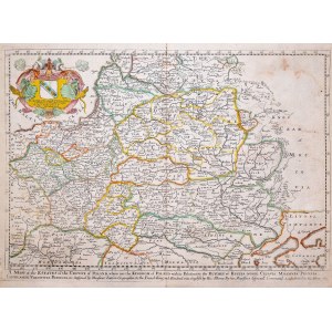
map taken from "A Geographical description of the World", first state, published by Richard Blome, London 1669
epoxy colored copperplate, 29 x 41 cm (plate imprint), very good condition, stain at top edge
condition not described in Imago Poloniae, earlier than K14/1


![Poland car map. Cracow [1945].](https://img1.one.bid/img/6508/1873705_1x.webp?1713823200)
![Poland car map. Cracow [1945].](https://img1.one.bid/img/6508/1873705_2x.webp?1713823200)


![[MAP]. MAP OF POLAND 1 : 500 000. OLSZTYN. [Sheet ] 3. w-wa 1947....](https://img1.one.bid/img/6363/1859794_1x.webp?1713045600)


Recently viewed
Please log in to see lots list
Favourites
Please log in to see lots list