


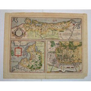
(POMORZE - Inflants - Oświęcim and Zator).
"Pomeraniae, Wandalicae Regionis, Typ.; Livoniae Nova Descriptio, Joanne Portantio auctore; Ducatus Oswieczensis, et Zatoriensis, Descriptio". Color copperplate. the map comes from the atlas: Ortelius A. - Theatrum orbis terrarum. Antverpiae (XVI/XVII c.) Format: 38.5 x 50 cm, (board: 46 x 58 cm).
Three maps made on one board; in the upper part a map of Pomerania (16 x 49.5 cm), in the lower part Inflants (22 x 24.3 cm) and Duchy of Auschwitz-Zator (22 x 24.2 cm). Map in passe-partout. Verso - text in Latin and pagina 103. traces of dampstain and browning, non. loss of right corner, non. underp. margin. Good condition.


Recently viewed
Please log in to see lots list
Favourites
Please log in to see lots list