POLSKA. Mapa ziem polskich z zaznaczonymi granicami rozbiorów; A. Blondeau, Hyacinthe Langlois
addYour notecreate
Lot description
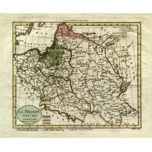
POLSKA. Mapa ziem polskich z zaznaczonymi granicami rozbiorów; ryt. A. Blondeau, pochodzi z:Guthrie, William, Atlas universel pour la géographie, wyd. Hyacinthe Langlois, Paryż 1798; miedz. kolor., st. bdb., lekkie zabrudzenia marginesów; wym. płyty: 238x195 mm; LA POLOGNE AVEC LES PARTAGES de 1772, 1793 et 1795;
LabelsBETA
Labels are assigned by artificial intelligence based on the recognized context of the image. The algorithm is constantly learning and we make every effort to make the results more accurate over time.


![[MAP]. MAP OF POLAND 1 : 500 000. OLSZTYN. [Sheet ] 3. w-wa 1947....](https://img1.one.bid/img/6363/1859794_1x.webp?1713045600)