


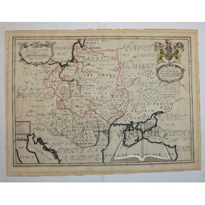
(POLAND, Ukraine). A new map of present Poland, Hungary, Walachia, Moldavia, Little Tartary;
&c.Shewing thier Principall Divisions Chief Cities, Towns, Rivers, &c. Dedicated to his Highness William Duke of Gloucester. Oxford ca. 1700 ( Compiled by Edward Wells, eng raved by Cole Benjamin.). Copperplate color. linear. Format: 36.5 x 51 cm (board: 41.5 x 55.5 cm).
Good condition. Title in upper right corner in decorative cartouche, surmounted by English coat of arms. This map, like the entire atlas, was dedicated to Prince William Glocester, who attended school in Oxford. The map covers the area from the Gulf of Venice and the Black Sea to the Baltic Sea. Central Europe including the Commonwealth and neighboring countries in the early 18th century from a British perspective. Edward Wells (1667-1727) - mathematician and geographer at Oxford University.


Recently viewed
Please log in to see lots list
Favourites
Please log in to see lots list