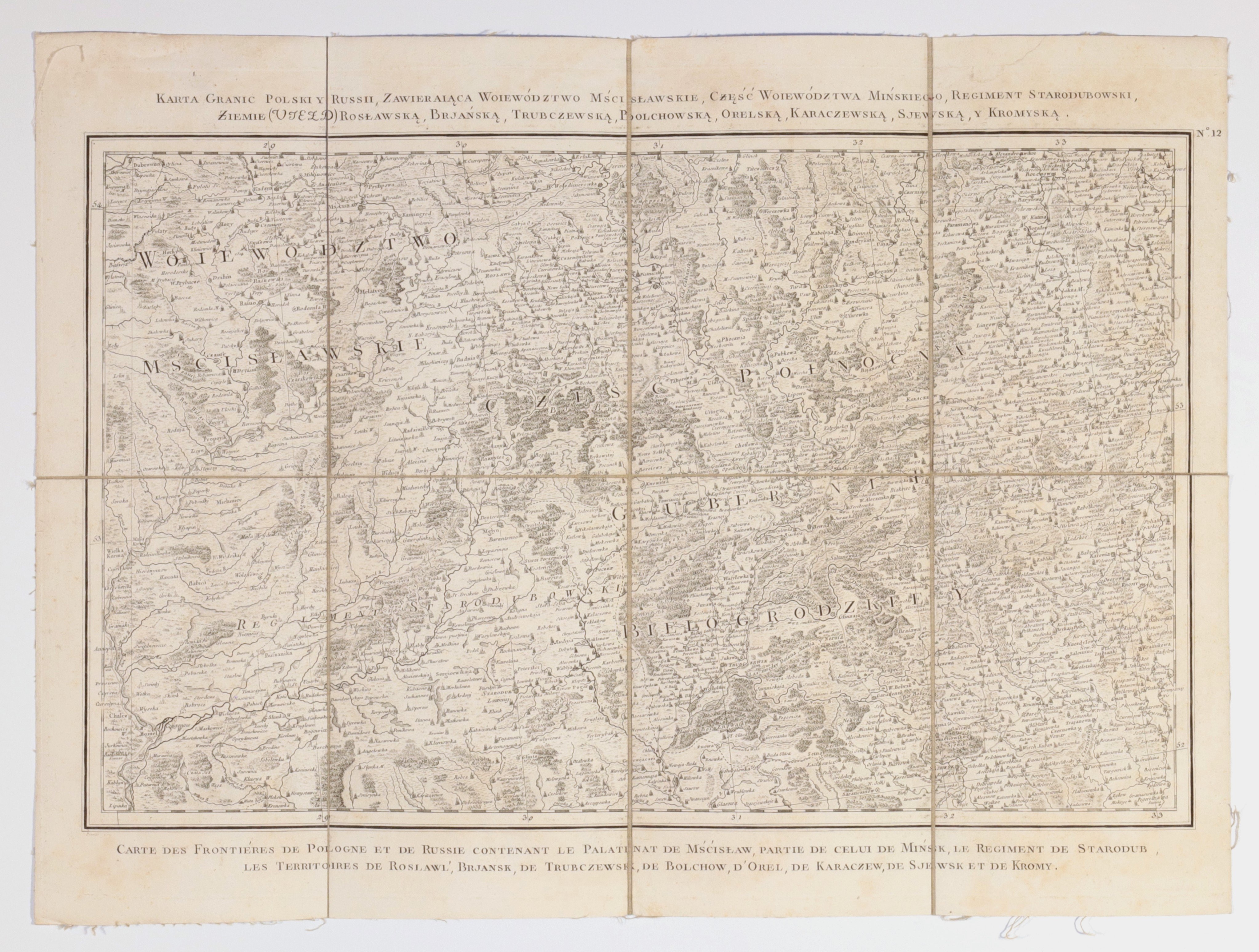
POLAND, GRAND DUCHY OF LITHUANIA, MSTISLAV PROVINCE, MINSK PROVINCE. Map showing the borderland between the Grand Duchy of Lithuania and Russia before the partitions; eng. Perrier, taken from the atlas: Carte de la Pologne divisée par provinces et palatinats et subdivisée par districts construite, oprac. G.B.A Rizzi-Zannoni (1736-1814), Paris, 1772; the atlas was created on the initiative of Jozef Aleksander Jablonowski (1711-1777); on the Polish side, Homel, Mstislavl Province and the eastern part of Minsk Province, as well as Horki (on the map as Horky, formerly Hory-Horki), from where the insurgents left in 1863; on the verso a signboard with a seal and handwritten description: Bolchow Starodub; miedz. cz.-b., st. bdb, map divided into eight sections glued together with linen; dimensions 575x425 mm; tit. bilingual: CARTE DES FRONTIÈRES POLAND Y RUSSIA, COMPRISING THE MSTISLAV PROVINCE, PART OF THE MINSK PROVINCE, THE STARODUBOV RGIMENT, LANDS (VIEZD) ROSLAVSKAYA, BRJANSKA, TRUBCHEVSKAYA, BOLCHOVSKAYA, ORELSKAYA, KARACHEVSKAYA, SJEVSKAYA, Y KROMYSKA; / CARTE DES FRONTIÉRES DE POLOGNE ET DE RUSSIE CONTENANT LE PALATINAT DE MŚĆISŁAW, PARTIE DE CELUI DE MIŃSK, LE REGIMENT DE STARODUB, LES TERRITOIRES DE ROSLAWL', BRJANSK, DE TRUBCZEWSK, DE BOLCHOW, D'OREL, DE KARACZEW, DE SJEWSK ET DE KROMY; VERY RARE.
![[MAP]. MAP OF POLAND 1 : 500 000. OLSZTYN. [Sheet ] 3. w-wa 1947....](https://img1.one.bid/img/6363/1859794_1x.webp?1713045600)


![Automobile MAP of Poland 1 : 2,000,000 with list of gas stations by 'Karpaty' Nakł. Karpaty Sp. z o.o., Lviv [1933].](https://img1.one.bid/img/6145/1794990_1x.webp?1709593200)
![Automobile MAP of Poland 1 : 2,000,000 with list of gas stations by 'Karpaty' Nakł. Karpaty Sp. z o.o., Lviv [1933].](https://img1.one.bid/img/6145/1794990_2x.webp?1709593200)