


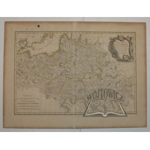
(POLAND). "Carte Generale de la Pologne...".
Copperplate color. line. Par M Rizzi Zannoni. Paris (ca. 1767). Map (No. 19) from the atlas: "Atlas moderne...", published by Jean Lattré. Format: 30 x 44.5 cm (board: 40.4 x 54.5 cm).
Traces of non-staining and browning. Good condition. Title in upper right corner in decorative cartouche with eagle motif, scale in lower left corner. Verso notes from the period. (Imago Poloniae: K58/1).


![[MAP]. MAP OF POLAND 1 : 500 000. OLSZTYN. [Sheet ] 3. w-wa 1947....](https://img1.one.bid/img/6363/1859794_1x.webp?1713045600)


![Automobile MAP of Poland 1 : 2,000,000 with list of gas stations by 'Karpaty' Nakł. Karpaty Sp. z o.o., Lviv [1933].](https://img1.one.bid/img/6145/1794990_1x.webp?1709593200)
![Automobile MAP of Poland 1 : 2,000,000 with list of gas stations by 'Karpaty' Nakł. Karpaty Sp. z o.o., Lviv [1933].](https://img1.one.bid/img/6145/1794990_2x.webp?1709593200)


Recently viewed
Please log in to see lots list
Favourites
Please log in to see lots list