


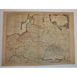
(POLAND and LITHUANIA). "Le Royaume de Pologne comprenant les etats de Pologne et de Lithuanie...".
Color copperplate. Jean Nicolas de Tillemont and Jean Baptiste Nolin. Paris 1697. second state. Format: 47 x 59.5 cm, (board: 48.5 x 61.2 cm).
Top left on drapery, board with explanation of territorial division (three columns). On the right, in the upper corner, a decorative information cartouche, with a scale below it. The offered map appeared both as a loose map and in several faux atlases, mainly those published by Nolin, such as "Le Theatre du Monde" (several editions after 1700). Map superficially glued to cardboard backing, non. tears, non. dampstain marks (Imago Poloniae K29/2). Rare.


![[MAP]. MAP OF POLAND 1 : 500 000. OLSZTYN. [Sheet ] 3. w-wa 1947....](https://img1.one.bid/img/6363/1859794_1x.webp?1713045600)


![Automobile MAP of Poland 1 : 2,000,000 with list of gas stations by 'Karpaty' Nakł. Karpaty Sp. z o.o., Lviv [1933].](https://img1.one.bid/img/6145/1794990_1x.webp?1709593200)
![Automobile MAP of Poland 1 : 2,000,000 with list of gas stations by 'Karpaty' Nakł. Karpaty Sp. z o.o., Lviv [1933].](https://img1.one.bid/img/6145/1794990_2x.webp?1709593200)


Recently viewed
Please log in to see lots list
Favourites
Please log in to see lots list