


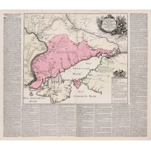
Military map illustrating the geostrategic situation at the beginning of the Russo-Austrian-Turkish War (1736-1739) in the area between the Don and the Dnieper, Augsburg, 1736
copperplate engraving colored in epoch, map size 38 x 44.5 cm, sheet size 57.5 x 66.8 cm
very good state of preservation, small tears and losses of the left and upper edge;
rarity


Recently viewed
Please log in to see lots list
Favourites
Please log in to see lots list