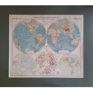
A real highlight will be this world map. It comes from the Stielers Handatlas atlas published by the cartographic publishing house Justus Perthes of Gotha, founded in 1785 and still in existence today. Stielers Handatlas (the full name is Hand-Atlas über alle Theile der Erde und über das Weltgebäude - Handy atlas of all parts of the world and the universe) was the main German atlas at the turn of the 20th century. Published for 30 years, it had ten editions from 1816 to 1945. Our map is the third map from the ninth edition, published between 1905 and 1924. Like many such publications of the 19th century, the atlas was not published at once in its entirety but in parts, the editions of which were often preceded by many months. The Ninth Edition contained 100 maps and was the first to be printed using lithographic cylindrical printing presses, which significantly reduced the cost of production and the price of the atlas, so that less affluent citizens could also learn about the world. And because the Germans were known for their cartographic precision, a selection of 16 maps from the atlas were translated into English, adapted to imperial units and became part of one edition of the famous Encyclopedia Britannica.
The map is framed in a dark green passe partout frame.


![[MAP]. MAP OF POLAND 1 : 500 000. OLSZTYN. [Sheet ] 3. w-wa 1947....](https://img1.one.bid/img/6363/1859794_1x.webp?1713045600)


![Automobile MAP of Poland 1 : 2,000,000 with list of gas stations by 'Karpaty' Nakł. Karpaty Sp. z o.o., Lviv [1933].](https://img1.one.bid/img/6145/1794990_1x.webp?1709593200)
![Automobile MAP of Poland 1 : 2,000,000 with list of gas stations by 'Karpaty' Nakł. Karpaty Sp. z o.o., Lviv [1933].](https://img1.one.bid/img/6145/1794990_2x.webp?1709593200)