


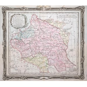
Map of the lands of the Republic of Poland from "Atlas Historique et Geographique", sixth state, published by Luis-Charles Desnos, Paris, 1790
colored copperplate, 28.5 x 32.3 cm (plate imprint)
very good condition
Imago Poloniae, K50/6


![Dahlberg Erik Jonsson [Puffendorf] - Dyneburg.](https://img1.one.bid/img/5856/1830362_1x.webp?1712095200)


![Dahlberg Erik Jonsson [Puffendorf] - Urbis et Arx Mitovia. .. Dobbleena Arx Cellciss. Curlandiae](https://img1.one.bid/img/5856/1830363_1x.webp?1712095200)


Recently viewed
Please log in to see lots list
Favourites
Please log in to see lots list