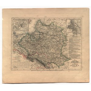
KRÓLESTWO POLSKIE. Mapa Królestwa Polskiego w 1815 r. oraz ziem I Rzeczypospolitej w 1772 r.; pochodzi z: Meyer's Zeitungs-Atlas, wyd. Schweinfurter Graviranstalt des Bibliographischen Inststituts, Hildburghausen, Amsterdam, Nowy Jork, ok. 1840; w górnych narożnikach niewielkie ramki z mapą okolic Wilna i planem Warszawy; zaznaczono granice podziałów rozbiorowych; stal. cz.-b. z kolorem liniowym, st. bdb., rdzawe plamki na marginesach; wym.: 249x185 mm; Die REPUBLIK POLEN nach ihrem Bestande im Jahre 1772 und das KÖNIGREICH POLEN seit dem Jahre 1815;
![[MAP]. MAP OF POLAND 1 : 500 000. OLSZTYN. [Sheet ] 3. w-wa 1947....](https://img1.one.bid/img/6363/1859794_1x.webp?1713045600)


![Königl. Freistadt Oedenburg [Sopron szabad királyi város térképe, 1871.] Lithographiert von F. Szita. W[iene]r...](https://img1.one.bid/img/6570/1844246_1x.webp?1712700000)
![Königl. Freistadt Oedenburg [Sopron szabad királyi város térképe, 1871.] Lithographiert von F. Szita. W[iene]r...](https://img1.one.bid/img/6570/1844246_2x.webp?1712700000)