


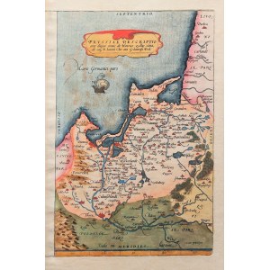
KINGDOM AND PRUSSIA. Map by H. Zell, Antwerp, ca. 1580; one of the variants of the first self-contained map of Prussia, edited by A. Ortelius; dedication to Danzig, on verso undated ownership stamp; copper color, st. bdb., fragment of left margin completed; map dimensions 195x302 mm; PRVSSIAE DESCRIPTIO ante aliquot annos ab Henrico Zellio edita, ab eoq3 D. Ioanni Clur. ciui Gedanensi Ded:.


![[MAP]. MAP OF POLAND 1 : 500 000. OLSZTYN. [Sheet ] 3. w-wa 1947....](https://img1.one.bid/img/6363/1859794_1x.webp?1713045600)


Recently viewed
Please log in to see lots list
Favourites
Please log in to see lots list