


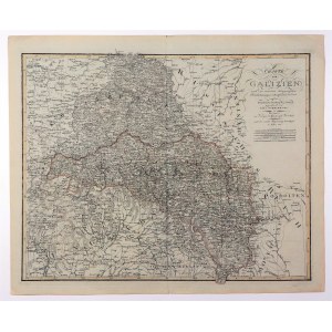
GALICIA. Map of Galicia with the so-called "Western Galicia" lost by Austria, which became part of the Congress Kingdom; drawn by G.R. von Schmidburg, published by Geographischen Instituts, Weimar 1817; copper b.-b. with line color, st. bdb, minor tears on atlas fold; plate dimensions 630x507 mm; CHARTE von GALIZIEN nach den neuesten astronomischen Ortsbestimungen entworfen, und revidirt auf der Sternwarte Seeberg bey Gotha [...].


![[MAP]. MAP OF POLAND 1 : 500 000. OLSZTYN. [Sheet ] 3. w-wa 1947....](https://img1.one.bid/img/6363/1859794_1x.webp?1713045600)


![Königl. Freistadt Oedenburg [Sopron szabad királyi város térképe, 1871.] Lithographiert von F. Szita. W[iene]r...](https://img1.one.bid/img/6570/1844246_1x.webp?1712700000)
![Königl. Freistadt Oedenburg [Sopron szabad királyi város térképe, 1871.] Lithographiert von F. Szita. W[iene]r...](https://img1.one.bid/img/6570/1844246_2x.webp?1712700000)


Recently viewed
Please log in to see lots list
Favourites
Please log in to see lots list