


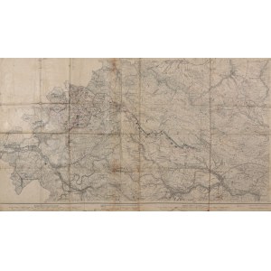
DUSZNIKI ZDRÓJ, LEWIN KŁODZKI. Topographical map of the area of the towns of Duszniki Zdrój and Lewin Klodzki (both in the south), Okrzeszyn in the north. Map from the period of the dispute over the Klodzko Basin between Poland and Czechoslovakia, used to polonize the geographical names of the Klodzko Basin, for this reason very rare (handwritten annotations with Polish place names and drawings indicating that the map was used by military staffers), compiled. 1882, published by Preussische..., 1919., part b.; st. db., folded, glued on linen, traces of flooding, moreover dirt and stains; dimensions ca. 875x490 mm. Lewin. 3242. reinerz, 3243.


![[MAP]. MAP OF POLAND 1 : 500 000. OLSZTYN. [Sheet ] 3. w-wa 1947....](https://img1.one.bid/img/6363/1859794_1x.webp?1713045600)


![Automobile MAP of Poland 1 : 2,000,000 with list of gas stations by 'Karpaty' Nakł. Karpaty Sp. z o.o., Lviv [1933].](https://img1.one.bid/img/6145/1794990_1x.webp?1709593200)
![Automobile MAP of Poland 1 : 2,000,000 with list of gas stations by 'Karpaty' Nakł. Karpaty Sp. z o.o., Lviv [1933].](https://img1.one.bid/img/6145/1794990_2x.webp?1709593200)


Recently viewed
Please log in to see lots list
Favourites
Please log in to see lots list