


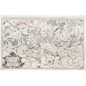
BRANDENBURG, NEW MARCHIA, BORDERLAND OF POLAND. Map of Brandenburg; showing the western part of the First Republic from Czaplinek in the north to Rawicz in the south; compiled by. Guillaume Sanson, ed. Alexis Hubert Jaillot, Paris after 1692; copper b.b. with line color, rebound from two plates, st. bdb., taped tears in left and lower margins, minor tear; plate dimensions (total) 900x575 mm; title in decorative shell cartouche in lower left corner: LE MARQUISAT ET ESLECTORAT DE BRANDEBOURG [...]; EXTREMELY IMPRESSIVE.


Recently viewed
Please log in to see lots list
Favourites
Please log in to see lots list