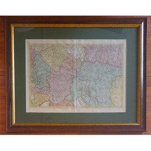

A map that is somewhat of a mystery to us, due to the anonymity of its author. However, it undoubtedly comes from an atlas (it bears No. 17) and depicts Central Europe divided into lands. Here we see Bohemia, Moravia, Silesia, Malopolska or Transylvania, among others.
It is worth noting that the map is hand-colored, which was not so common in the old days.
It is framed in a dark green passe partout frame, as well as a wooden, gilded frame and additionally protected by glass. Like all of our featured objects it is ready to hang at home.
Dimensions:
535 x 675 mm (all in wooden frame)
450 x 585 mm (in passe partout only)
approx. 345 x 480 (map only)
Beautiful state of preservation.


![[MAP]. MAP OF POLAND 1 : 500 000. OLSZTYN. [Sheet ] 3. w-wa 1947....](https://img1.one.bid/img/6363/1859794_1x.webp?1713045600)