


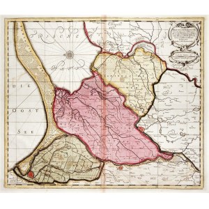
ROYAL PRUSSIA, ¯U³AWY WI¶LANE, GDANSK, ELBLAG. Map of the Vistula Zulawy with schematic plans of Danzig, Malbork, Tczew and Elblag; different colors mark the Zulawy of Danzig, Malbork and Elblag; compiled. for military purposes by the Swedish military cartographer Olaus Johannes Gothus (Olaf Hanson Svart) during the Thirty Years' War; first published by Johannes Janssonius in 1641, this Piece published by Petrus Schenk and Gerard Valck (under the title cartouche, publisher's note: Amstelodami Venditant P. Schenk, et G. Valk. Cum Priv.), Amsterdam after 1686, eastern orientation; copper. color, f.p., f.p., on verso locally glued with paper, traces of moisture; plate dimensions 480x410 mm; TRACTUUM BORUSSIAE, circa Gedanum et Elbingam [...]; [cf .Dantiscum ....G81/1, but different publisher, and publisher's signature under the title cartouche, not above the lower frame].


![Dahlberg Erik Jonsson [Puffendorf] - Plan of the Baltic coast, from Danzig and Vistula to the spit of Hel](https://img1.one.bid/img/5856/1829282_1x.webp?1712008800)


Recently viewed
Please log in to see lots list
Favourites
Please log in to see lots list