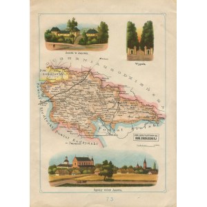
22x30 cm. Very good condition (minimal loss in upper left corner).
Color map of Konstantynów county in Siedlce Gubernia, with illustrations showing, among other things, the castle in Janów. Comes from Jozef Michal Bazewicz's work "Geographical Atlas Illustrated of the Polish Kingdom," published in 1903-1907.


![[MAP]. MAP OF POLAND 1 : 500 000. OLSZTYN. [Sheet ] 3. w-wa 1947....](https://img1.one.bid/img/6363/1859794_1x.webp?1713045600)


![Dalhberg Erik Jonsson [Puffendorf] - Map of the Kingdom of Denmark and Pomerania (Szczecin)](https://img1.one.bid/img/5856/1829209_1x.webp?1712008800)