


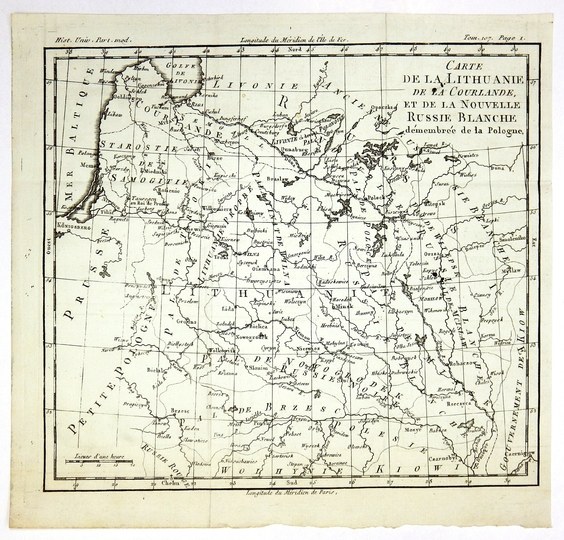
[LITHUANIA]. Carte de la Lithuanie, de la Courlande, et de la Nouvelle Russie Blanche démembrée de la Pologne. Copperplate form. 23.2x26 cm.
Map of Lithuania and adjacent countries by Louis Brion de la Tour. The map was published in: "Histoire Universelle depuis le commencement du monde", vol. 107 (Paris 1788). Title in upper right corner, linear scale in lower left corner. In the upper margin, information about the title of the work and the volume number. Cartographic grid. Traces of folding.


![[MAP]. MAP OF POLAND 1 : 500 000. OLSZTYN. [Sheet ] 3. w-wa 1947....](https://img1.one.bid/img/6363/1859794_1x.webp?1713045600)
![Poland car map. Cracow [1945].](https://img1.one.bid/img/6508/1873705_1x.webp?1713823200)
![Poland car map. Cracow [1945].](https://img1.one.bid/img/6508/1873705_2x.webp?1713823200)
![Map of Bydgoszcz area [ca] 61x45, [post 1922].](https://img1.one.bid/img/6474/1885259_1x.webp?1714687200)
![Map of Bydgoszcz area [ca] 61x45, [post 1922].](https://img1.one.bid/img/6474/1885259_2x.webp?1714687200)
![Dalhberg Erik Jonsson [Puffendorf] - Map of the Kingdom of Denmark and Pomerania (Szczecin)](https://img1.one.bid/img/5856/1829209_1x.webp?1712008800)
![[DE FER Nicholas] STETIN ville Forte d'Allemagne [SZCZECIN - Fortified City of Germany, Capital of Royal Pomerania] Paris. 1691.](https://img1.one.bid/img/6508/1873735_1x.webp?1713823200)
![[DE FER Nicholas] STETIN ville Forte d'Allemagne [SZCZECIN - Fortified City of Germany, Capital of Royal Pomerania] Paris. 1691.](https://img1.one.bid/img/6508/1873735_2x.webp?1713823200)


Recently viewed
Please log in to see lots list
Favourites
Please log in to see lots list