


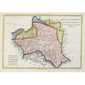
[POLAND]. Royaume de Pologne, et Duché de Lithuanie. Colorized copperplate form. 23.3x34.4 cm.
Imago Pol. K50/13. Map of Poland and Lithuania by Rigobert Bonne, published in Paris in 1787. The plate was engraved by M. André (signed under the lower frame on the right). The map was part of the "Atlas encyclopédique" (Paris 1787). Title in upper right corner, 6 linear scales in lower left corner. Above the upper frame on the right No. "72". No geographical content outside Poland and Lithuania. Line and surface color (later?). Vertical folds of the sheet, minor soiling.


![Poland car map. Cracow [1945].](https://img1.one.bid/img/6508/1873705_1x.webp?1713823200)
![Poland car map. Cracow [1945].](https://img1.one.bid/img/6508/1873705_2x.webp?1713823200)


![[MAP]. MAP OF POLAND 1 : 500 000. OLSZTYN. [Sheet ] 3. w-wa 1947....](https://img1.one.bid/img/6363/1859794_1x.webp?1713045600)


Recently viewed
Please log in to see lots list
Favourites
Please log in to see lots list