


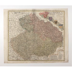
SLĄSK. A map of Silesia, Bohemia, Moravia and Lusatia from the mid-18th century; compiled by. Tobias Mayer, J.W. Wieland, J.C. Müller, published by the Oficyna Spadkobierc Hanmann, Nuremberg 1748; title separated from the map by the coats of arms of Bohemia, Moravia, Silesia and Lusatia; above the upper frame, second title: Carte des ÉTATS DE BOHEME [...]; copper color, fair condition, light soiling; plate dimensions 565x500 mm; REGNI BOHEMIAE, DVC. SILESIAE, MARCHIONATVVM MORAVIAE et LVSATIAE [...].


![SLĄSK. Map of Silesia; compiled by. T. Mayer, taken from: Atlas Silesiae [...], published by Oficyna Spadkobierców Homanna](https://img1.one.bid/img/6586/1882744_1x.webp?1714428000)


![UPPER SILESIA, CIESZYN, RACIBÓRZ, OPOLE, OPAWA, KARNIÓW, ZĄBKOWICE ŚLĄSKIE, NYSA, ZIĘBICE. Map of Upper Silesia; compiled by. J.M. Haas, taken from: Atlas Silesiae [...].](https://img1.one.bid/img/6586/1882748_1x.webp?1714428000)


Recently viewed
Please log in to see lots list
Favourites
Please log in to see lots list