


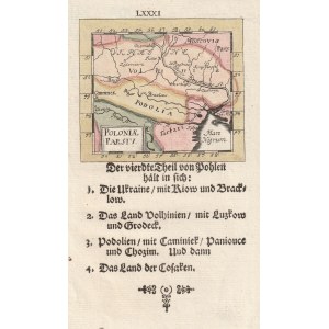
POLAND (called KORONA in the First Republic). Map of the Polish lands - book card from Gabriel Bodenehr's miniature atlas, compiled by. Johann Ulrich Müller, 1702; copper color, st. bdb.; map dimensions: 79x68 mm; POLONIAE PARS IV.


Recently viewed
Please log in to see lots list
Favourites
Please log in to see lots list