


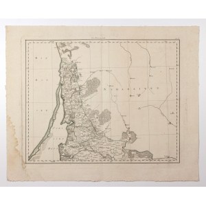
PRUSSIAN LITHUANIA, KLAJPEDA (MEMEL) WITH TAUROGI COUNTY. Map of Prussian Lithuania - the first sheet of a map of East Prussia, composed of five separate sheets; showing forests in the vicinity of Garsden (Polish: Gorżdy, Lithuanian: Gargždai) and Garden (Polish: Gordoma, Lithu anian:Gardamas); eng. Anton Amon, taken from the work of F.A. Schraembl's Allgemeiner Grosser Atlass, ed. by P.J. Schalbacher, Vienna 1787-1788; copper b/w with line color, st. bdb., rust spots, left p. trace of moisture; plate dimensions 595x483 mm; tit. above upper frame: Ost Preussen I Bl.; RARE.


Recently viewed
Please log in to see lots list
Favourites
Please log in to see lots list