


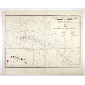
[KARPATES]. Oil and gas areas of Poland in the Carpathians and foothills. Color map form. 64x92.5 cm.
Map elaborated. by Konstanty Tolwiński, published by the Carpathian Geological Station in Boryslaw in 1928. Printed in Lviv by Zakł. Graf. "Ksiaznica-Atlas." Title (in Polish and English) in trapezoidal frame in upper right corner, scale there (1:500,000), linear scale and legend. In the lower left corner a side map "Oil and gas mines in the Carpathians and foothills." The map was an appendix to the Bulletin of the Carpathian Geological Station, No. 16. Folding marks, good condition.


![[MAP]. MAP OF POLAND 1 : 500 000. OLSZTYN. [Sheet ] 3. w-wa 1947....](https://img1.one.bid/img/6363/1859794_1x.webp?1713045600)
![Poland car map. Cracow [1945].](https://img1.one.bid/img/6508/1873705_1x.webp?1713823200)
![Poland car map. Cracow [1945].](https://img1.one.bid/img/6508/1873705_2x.webp?1713823200)


![Dalhberg Erik Jonsson [Puffendorf] - Map of the Kingdom of Denmark and Pomerania (Szczecin)](https://img1.one.bid/img/5856/1829209_1x.webp?1712008800)


Recently viewed
Please log in to see lots list
Favourites
Please log in to see lots list