


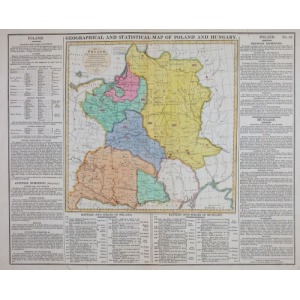
Miedzioryt kolorowany, papier; 47 x 57 cm
Geographical and statistical map of Poland and Hungary
Publ: Lavoisine's Complete Genealogical, Historical and Chronological Atlas, wyd. John Barfield, Londyn, 1814
Estymacja 400 - 500


![Poland car map. Cracow [1945].](https://img1.one.bid/img/6508/1873705_1x.webp?1713823200)
![Poland car map. Cracow [1945].](https://img1.one.bid/img/6508/1873705_2x.webp?1713823200)


![[MAP]. MAP OF POLAND 1 : 500 000. OLSZTYN. [Sheet ] 3. w-wa 1947....](https://img1.one.bid/img/6363/1859794_1x.webp?1713045600)


Recently viewed
Please log in to see lots list
Favourites
Please log in to see lots list