Advanced search Advanced search
637

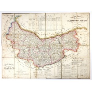
MAZOWSZE. J. Kolberg's Mappa jeneralna Woiewodztwa Mazowieckie of 1827.

add Your note 
Lot description Show orginal version
[MAZOWSZE]. Mappa jeneralna Woiewodztwa Mazowieckiego. Arranged according to the best sources by Julius Colberg. Carte génerale du Palatinat de Masovie dressée d'apres les meilleures sources. Colored lithograph form. 43x57.7 cm.
Map elaborated. by Juliusz Kolberg taken from his "Atlas of the Kingdom of Poland" (CKZK 5, 82), printed in Warsaw in 1827 at the School Lithographic Institute, lithographed by J. Slawinski. Titles in the upper right and lower left corners, in the lower right corner a legend, under the upper and above the lower frame tables with territorial division and statistical data. Above the lower left frame two linear scales. Linear color. Map cut into 12 parts glued together on linen. Clear browning of paper in places .
Auction
136th antiquarian auction (15/16-10-2022)
gavel
Date
15 October 2022 CEST/Warsaw
date_range
Start price
77 EUR
Hammer price
84 EUR
Overbid
110%
Views: 79 | Favourites: 3
Auction

Antykwariat RARA AVIS

136th antiquarian auction (15/16-10-2022)
Date
15 October 2022 CEST/Warsaw
Lots bidding

All lots are listed to bid

Buyer's premium
10.00%
OneBid does not charge additional fees for the bidding.
Bid increments
  1
  > 5
  50
  > 10
  200
  > 20
  500
  > 50
  1 000
  > 100
  2 000
  > 200
  5 000
  > 500
  10 000
  > 1 000
  20 000
  > 2 000
  50 000
  > 5 000
  100 000
  > 10 000
 
Terms and Conditions
About the Auction
FAQ
About the Seller
Antykwariat RARA AVIS
Contact
Antykwariat "RARA AVIS" s.c.
room
ul. Szpitalna 11
31-024 Kraków
phone
+48124220390
Opening hours
Monday
10:00 - 18:00
Tuesday
10:00 - 18:00
Wednesday
10:00 - 18:00
Thursday
10:00 - 18:00
Friday
10:00 - 18:00
Saturday
10:00 - 14:00
Sunday
Closed
keyboard_arrow_up