


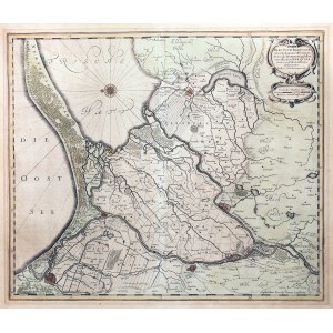
GDANSK. Schematic plan of Danzig with map of Zulawy Wislane; compiled. for the Swedish army by J. H. Svart (= O. J. Gotho) during the Thirty Years' War, published by J. Janssonius, Amsterdam 1641; eastern orientation; copper color; st. bdb., pas.-part., atlas folding, yellowed paper; plate dimensions: 488x415 mm; Tractuum Borussiae, circa Gedanum et Elbingam...; [Imago Poloniae... K102/1, Dantiscum... G81/1, Cartography... 138].


![Dahlberg Erik Jonsson [Puffendorf] - Plan of the Baltic coast, from Danzig and Vistula to the spit of Hel](https://img1.one.bid/img/5856/1829282_1x.webp?1712008800)


![[MAP]. MAP OF POLAND 1 : 500 000. OLSZTYN. [Sheet ] 3. w-wa 1947....](https://img1.one.bid/img/6363/1859794_1x.webp?1713045600)
![Poland car map. Cracow [1945].](https://img1.one.bid/img/6508/1873705_1x.webp?1713823200)
![Poland car map. Cracow [1945].](https://img1.one.bid/img/6508/1873705_2x.webp?1713823200)


Recently viewed
Please log in to see lots list
Favourites
Please log in to see lots list